
This year’s seminar series began with a fascinating travel presentation about a two-week sailboat trip from Largs to Kerrara Island and back with an exploration of medieval archaeology on the islands in between. The talk was delivered by Dr Stephen Harrison and Professor Stephen Driscoll, lecturers in Archaeology at the University of Glasgow.
Before introducing the speakers, Dr Simon Taylor, linguist and place-names expert, explained the context and background of this maritime trip. The idea came directly out of 2017 Dunkeld to Iona walk (presented in the following week’s seminar) to develop insight on the sea faring experiences of the Dal Riatan clergy. Dr Taylor briefly informed the namescape of the island world explored in the trip: out of the 11 islands visited, 5 had Norse names (Sanda, Texa, Oronsay, Kerrara, and Gigha), 3 Gaelic names (Garbh Eileach, Eileach an Naoimh, Eilean Mor) and two pre-Gaelic, early Celtic or even earlier (Rathlin and Bute) and one English name, Holy Island – a namescape that spanned two millennia. In the past, these islands were significant along major sea routes. Dr Taylor then shared his main insights from the trip that sailing through this part of Atlantic he started seeing these small island as important refuges for sea travellers like hospices for travellers along more difficult routes on land. These islands weren’t just brief stops along sea routes but had to cater for sailors even through longer stretches of unfavourable weather conditions. For this reason, it was not surprising to find chapels providing space for daily liturgy for travelling clergy.
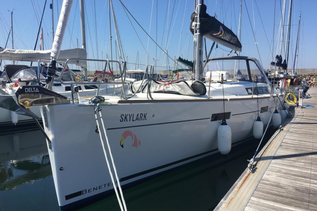
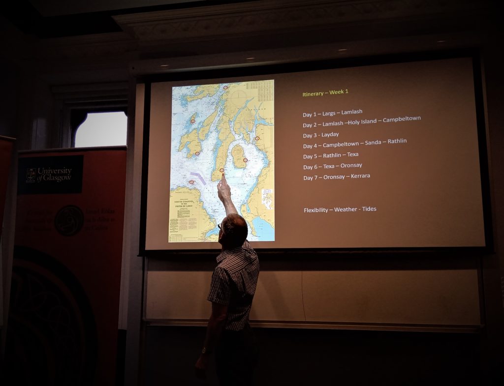
Dr Stephen Harrison, a Viking archaeology expert as well as an experienced sailor and sailboat enthusiast, then took over to explain the more technical sailing aspects of this trip. Dr Harrison recounted the trip from a phenomenological perspective on seascape archaeology, focusing on the embodiment of the surrounding landscape and human experiences of navigating the seas. This perspective affords thinking about sea routes and navigation, physically reengaging with medieval sea voyages. In this way, the trip was an experiential exercise rather than an interpretive experiment that would have required travelling in medieval boat replicas. To shed light on the taken-for-granted modern advancements in sailing, Dr Harrison compared the experiences of sailing with their hired yacht Skylark with sailboats in the past. Compared to a Viking boat, Skylark was slightly faster and had the advantage of an engine making it independent from wind speed. He pointed out that there is a major difference in terms of engagement with the wind conditions: wind speed and direction was much more of a determining factor in medieval sailing. The idea of safe harbour is also different today than it was in the Middle Ages, determined by sailboat construction: Skylark draft was 2.3 metres which required additional considerations for low tide water levels, approach and anchoring place in a harbour – issues much less relevant to smaller and lighter medieval boats that could reach shallower waters. More life-changing differences exist in comparisons of sea navigation techniques. The team had touch screen computer navigation on board Skylark which consistently informed about speed and direction, calculating leeway and impact of the tidal flows. Although a taken-for-granted technology today, Dr Harrison reminded how revolutionary this is even compared to recent modern technologies, not to mention traditional techniques that could only estimate boat speed and travel direction or depth sound with weights for navigation – all highly dependent on weather conditions. Despite the differences, tides and tidal flows are a constant and timing sailing with the tides would have resembled that of today. The onwards itinerary followed Largs to Lamlash, Holy Island to Campbeltown, Sanda to Rathlin, Texa to Sound of Islay and Oronsay to Kerrara. The schedule was dependant on weather conditions – in the absence of boat engine the trip would have taken much longer than 7 days. Dr Harrison pointed out that timing approach to different islands in this seascape as well as using the tidal flows and currents to one’s advantage would have required good local knowledge. He contrasted the timing of anchorage for Texa and Sanda where the former has a safe harbour while the latter is surrounded by dangerous tidal flows. The sum of variable sea conditions makes islands differ greatly in accessibility.
Professor Steve Driscoll, an expert on the Early Historic period in Scotland, focused his account of the trip on the medieval sites visited on the return route. He was particularly interested in castles and the affordances of their locations in this island landscape. He also had a chance to visit remote religious sites, questioning their perceived remoteness during the trip. Prof Driscoll joined the return trip in Oban – the castle there is a well-documented early medieval castle of Dunollie situated in a conspicuous location which dominates the harbour with control over access and anchorage and good visibility of the seascape. Onwards to Garvellachs, they visited Dun Chonaill, a medieval castle fort provided with interpretation signs. Although the castle occupies a prominent place in the landscape, Prof Driscoll identified that landing with boat may have been difficult along its rocky island shore, affording only a narrow boat inlet. The site has early structural remains of an ecclesiastical site with evidence of later rebuilding, as well as cereal cultivation marks, holy wells, shrines, inscribed stone cairns and curious subterranean structures, all of which suggest intense activity on this seemingly remote island.

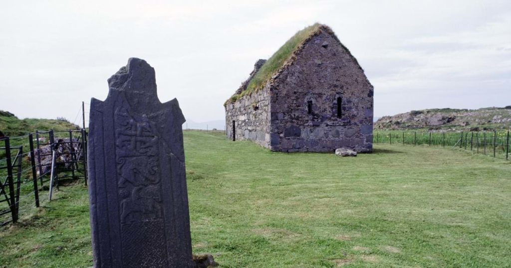
Eilean Mor was another monastic island visited along the route and although small in size, it was certainly attractive for early medieval pilgrimage, obvious in remains of stone monuments including a cross shaft, multiphase chapel and a late medieval cross replica (original in the National Museum) as well as a possible hermit’s cave with Christian crosses pecked on the walls. The next site was Cladh a’ Bhile, Ellary, the most remote of all those visited, an overgrown landscape housing a large collection of early stone sculpture, gravestones and replica crosses, however, without interpretation signs. Prof Driscoll interpreted this place as a 6-7th century sacred burial ground that is possibly associated with kingship. The trip continued onto the scenic island of Gigha, visiting the site of Kilchattan, a ruinous chapel site with important ogham stone inscription, followed by a return to Campbeltown, an old church site of Kilkerran, home to many medieval stone crosses, including bases and shafts of crosses reused for later post-medieval churchyard purposes. Another castle was encountered at Lochranza, Arran, an easy harbour with monitoring vistas onto Kintyre. Upon landing at Dunagoil Bay, Bute, the final site visit was the impressive St Blane’s church. Prof Driscoll concluded that all the sites visited are connected places situated at prominent landscape locations with good visibility onto the next site. In closing, he shared his personal reflections on the connectivity between these monastic places – from the perspective of travelling by sea he questioned the remoteness and accessibility of these small island places, not only in the Middle Ages but also today as most sites were provided with Historic Scotland interpretation signs for the visiting members of the public.
This would have been a really interesting experience if I had been present to hear what both Professor Driscoll and Doctor Harrison made of their particular journeys by the old sea routes taken by the early medieval travellers.
I have been fortunate to visit some of the places mentioned ( St.Blane’s Church, Kingarth, Bute, Kilkerran,Campbelltown and St Cathan’s Church, Kilchattan, Gigha and wondered if there would be a book to follow of their experiences or a publication of some kind which would be available to the general public. I was presented with a beautiful book “Sacred North” when I left Glasgow to live in Rosehearty and some sites are mentioned in it.